

A.K. Jain is one of India’s leading urban planners, architects, and authors, with decades of experience in shaping the country’s planning and development policies. A former Commissioner (Planning) of the Delhi Development Authority (DDA), he has played a significant role in urban planning, regional development, heritage conservation, and sustainable growth. He served as a Member of the Ministry of Housing and Urban Affairs Committee on DDA 2015 and was associated with UN-Habitat (2007–2012). His contributions have been recognized through several prestigious honours, including the Second Urban Professional Award at the World Urban Forum (Medellín, Colombia, 2014), the IBC Lifetime Achievement Award 2024, the “Living Legend” Award by the Indian Institute of Architects (Northern Chapter) in 2022, and the Smart Habitat Foundation Lifetime Achievement Award 2022. Through his books and research, A.K. Jain continues to inspire architects, planners, policymakers, and researchers with his vision for sustainable rural development and resilient, future-ready cities.
In this exclusive conversation with The Architecture and Planning News (TheAPN). He traces nearly four centuries of Delhi’s planning journey, explaining how history, governance and visionary leadership shaped the capital—and why understanding the past is essential for planning its future.
TheAPN: You have witnessed Delhi’s transformation over several decades—as a planner, administrator and policy adviser. How would you describe Delhi’s current planning stage? Is it at a turning point, or is it merely responding to accumulated urban challenges?
A.K. Jain: Before answering that question, it is important to understand the historical evolution of Delhi’s planning.
While many describe Delhi as a city with a history spanning over 2,000 years, the modern planning of Delhi effectively began in 1648, when Mughal Emperor Shah Jahan shifted the capital from Agra to Delhi. The decision was strategic. Delhi occupied a central location within the Mughal Empire, making it easier to administer territories extending from Kashmir to Lahore and beyond. Situated on an important trade route, the city was ideally positioned for governance as well as commerce.
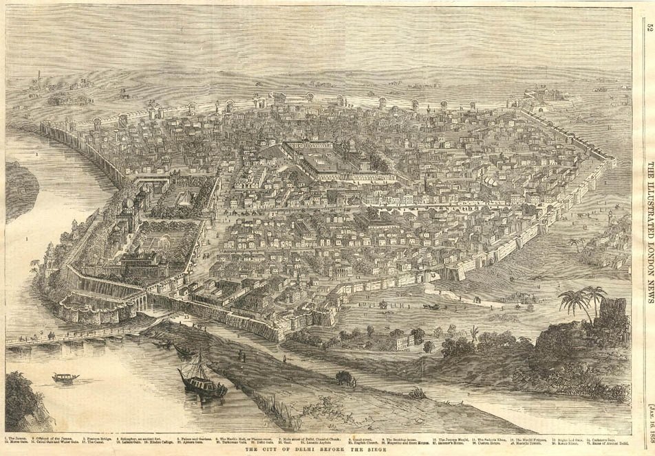
Shahjahanabad was planned over nearly 1,800 acres along the banks of the River Yamuna. What is remarkable is that, although the term “15-minute city” has become fashionable only in recent years, Shahjahanabad had already embodied that principle centuries ago. Since motor vehicles did not exist, the city functioned entirely as a pedestrian-oriented settlement. Residents could comfortably reach most destinations within about fifteen minutes on foot, or by simple modes of transport such as tongas or hand-pulled rickshaws.
The city’s planning was equally significant from a social perspective. Housing was not designed exclusively for the affluent; it accommodated people from every economic background, including the poor. The concepts of katras and mohallas were based on occupational communities. For instance, Katra Neel was associated with indigo traders and workers, while Dariba became the centre for jewellers and their craftsmen. These neighbourhoods created cohesive social units, fostering strong community life while supporting local commerce.
Commercial activity naturally flourished along the city’s principal streets. Interestingly, there were no rigid land-use controls during that period. In many ways, this proved advantageous. Trade operated with considerable freedom, enabling Delhi to emerge as one of the wealthiest commercial centres of its time. Jewellery, textiles, carpets and numerous other products were exported across the world, attracting merchants from distant regions.
Equally important was the city’s relationship with the River Yamuna. The river was not treated as a peripheral feature; it was an integral part of everyday urban life. People visited the river daily for bathing, religious rituals and festivals. The Red Fort, located on the riverfront, formed the royal seat of power, while the Jama Masjid dominated the city’s skyline, together creating a powerful urban composition that defined Shahjahanabad’s identity. One simply cannot imagine Shahjahanabad without the Yamuna.
Unfortunately, this intimate relationship between the city and its river gradually weakened. During the 1950s, the construction of the Ring Road physically separated people from the riverfront. Subsequently, memorials, including Raj Ghat and other samadhis, were developed along the river, further restricting public access. Instead of becoming the city’s front yard, the riverfront gradually turned into its backyard.
The situation deteriorated further when thermal power stations and sanitary landfills were established along the Yamuna. At the time, these riverfront lands were wrongly perceived as vacant wasteland suitable for undesirable land uses. This decision had long-term consequences for Delhi’s environmental and urban development.
Before the Delhi Development Authority came into existence, urban planning responsibilities rested with the Delhi Improvement Trust (DIT), established in 1937, a few years after the inauguration of New Delhi in 1931. The DIT emerged partly because national leaders, including Mahatma Gandhi and Aruna Asaf Ali, questioned the British administration about its plans for the city’s indigenous population. While New Delhi was being developed as the imperial capital, the older parts of Delhi also required planned improvements.
Between 1937 and 1957, the Delhi Improvement Trust developed approximately 10,000 acres of land. It planned industrial areas, including Northern Extension/Birla Mill, Najafgarh Road Industrial Area/DCM, and implemented several residential schemes in locations such as Civil Lines, New Sabzi Mandi and Malkaganj. Nearly sixty planning schemes were prepared during this period.
However, the British planning philosophy reflected colonial priorities. New Delhi was conceived as an exclusive administrative enclave that needed protection from the surrounding native settlements. Even the railway embankment constructed between what are now Tilak Bridge and Minto Bridge was intended to serve as a defensive barrier, enabling military control in the event of unrest.
Everything changed after Independence in 1947. Delhi’s population stood at around nine lakh, but the Partition triggered one of the largest human migrations in history. Within a matter of months, approximately five lakh refugees arrived from the newly created Pakistan. They occupied every available open space, including Connaught Place, Purana Qila, Feroz Shah Kotla, parks and roadside areas.
Recognizing that these displaced families required permanent rehabilitation rather than temporary relief, Prime Minister Jawaharlal Nehru transformed the Ministry of Refugees into the Ministry of Rehabilitation. The government planned 36 rehabilitation colonies, including 3 Patel Nagars, 2 Rajinder Nagars, Rajouri Garden, Malviya Nagar, Kalkaji and Gandhi Nagar. Refugees were allotted modest residential plots of approximately 80–100 square yards at highly subsidized prices, making long-term rehabilitation possible. Many of these neighborhoods have since evolved into some of Delhi’s most prosperous residential areas.
Despite these achievements, Nehru believed that Delhi deserved more than piecemeal development. As the national capital, it required a comprehensive planning framework rather than isolated responses to immediate problems. In 1951, the Delhi Improvement Trust InquiryCommittee, commonly known as the G.D. Birla Committee, was established. After an extensive review, the committee made two landmark recommendations: Delhi should adopt a comprehensive Master Plan, and fragmented municipal bodies should be unified under a single municipal administration.
These recommendations ultimately led to two landmark legislations enacted in 1957—the Delhi Development Act and the Delhi Municipal Corporation Act. They resulted in the establishment of the Delhi Development Authority (DDA) and the unified Municipal Corporation of Delhi (MCD).
The DDA was entrusted with planning, land development and housing, while the Municipal Corporation became responsible for civic services. The first and most important responsibility assigned to the newly created DDA was the preparation of Delhi’s first comprehensive Master Plan.
Since the DDA initially lacked adequate technical capacity, the Government of India established the Town Planning Organisation (TPO) under the Ministry of Works and Housing. Indian planners working overseas were invited to return and contribute to this national effort. The Ford Foundation also provided technical support. Together, they prepared the Interim General Plan in 1959, which was refined after public consultation and eventually approved in 1962 as the Master Plan for Delhi (MPD-1962).
Prime Minister Nehru took the unusual step of presenting the Master Plan before Parliament, even though the law did not require parliamentary approval. His intention was symbolic. He wanted Delhi’s Master Plan to become a national example, encouraging every state capital in India to adopt systematic, planned urban development rather than relying on ad hoc expansion.
The Evolution of Delhi’s Master Plans
TheAPN: How did Delhi’s planning evolve after the 1962 Master Plan, and what were the major milestones that shaped the city’s planning philosophy?
A.K. Jain: The 1962 Master Plan marked a turning point in India’s planning history. It was the country’s first comprehensive master plan and became a benchmark for urban planning across the nation. Naturally, it attracted criticism—as every major planning exercise does—but its significance cannot be overstated.
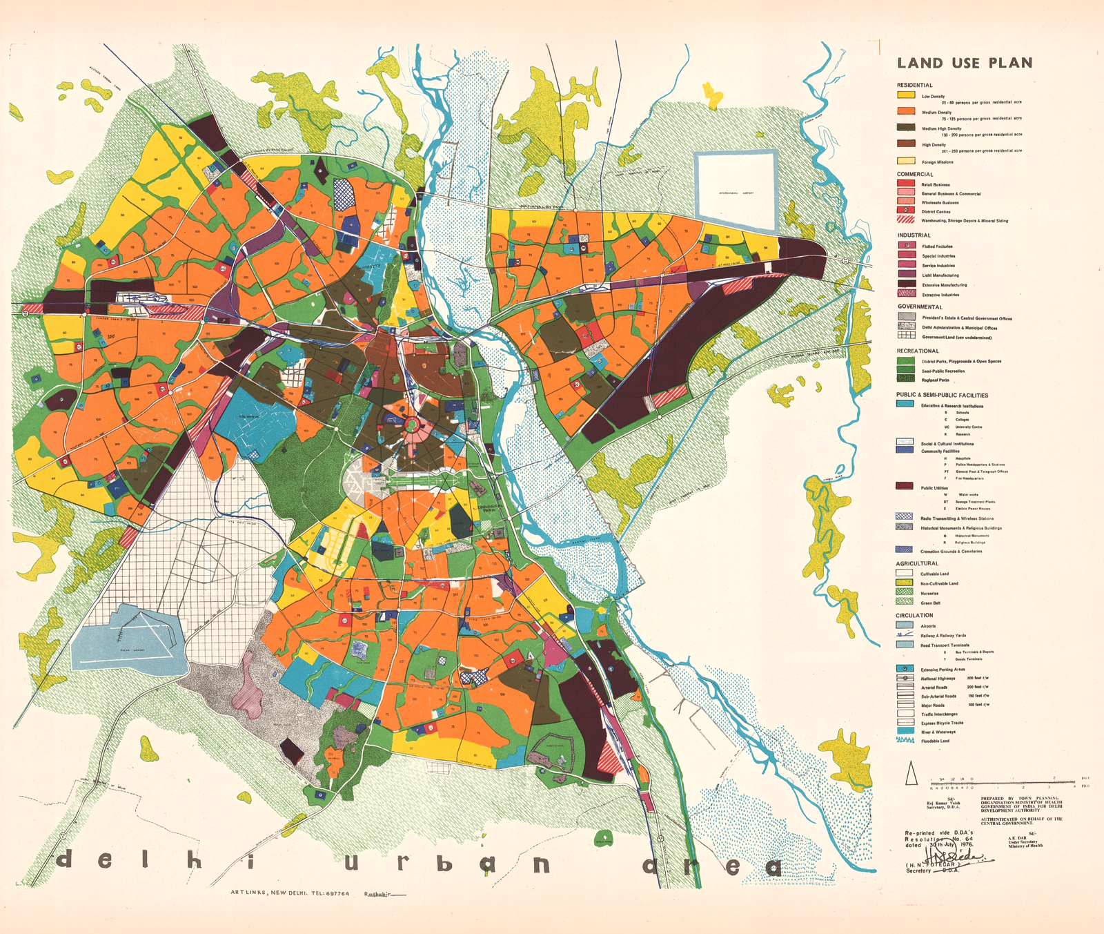
One of the earliest observations was that Delhi’s problems could not be solved within its administrative boundaries alone. Challenges such as water supply, electricity, labour movement and migration were closely linked to neighbouring states, including Haryana, Uttar Pradesh and Punjab. This led to the realisation that Delhi required a regional planning framework rather than an isolated city plan.
As a result, the Government of India enacted the National Capital Region (NCR) Planning Board Act, and in 1985 the NCR Planning Board was established. Initially, it prepared a Regional Plan covering an 80-kilometre radius around Delhi, which was later expanded to 100 kilometres. The objective was to coordinate development across the wider National Capital Region rather than allowing Delhi to grow in isolation.
Another significant milestone came during the tenure of Prime Minister Indira Gandhi. She was deeply familiar with Delhi and closely observed its physical development. During one of her visits to Connaught Place in the mid-1970s, she noticed that newly constructed multi-storey buildings lacked visual harmony. Unlike Lutyens’ Delhi, which followed a coherent urban design language, these buildings appeared disconnected in height, form and architectural character.
Concerned about this trend, she convened a meeting and questioned how such developments were being approved. The issue, she felt, was not merely about individual buildings but about the overall visual character of the city. It became evident that planning had focused largely on land use and engineering, while aesthetics and urban design had received far less attention.
On the suggestion of Patwant Singh, who was closely associated with design and architecture, the Government established the Delhi Urban Art Commission (DUAC) through an Act of Parliament. The Commission’s primary objective was to move Delhi from two-dimensional planning to three-dimensional planning. Urban planning, Mr. Jain explains, should not stop at allocating land uses or transportation networks; it must also address how buildings relate to one another, how public spaces are designed and how the city’s visual identity is preserved. Although the DUAC initially placed greater emphasis on the NDMC area, its mandate extended across Delhi.
Around the same period, the New Delhi Redevelopment Advisory Committee (NDRAC) also worked on improving the design quality of zonal plans before its responsibilities were eventually transferred to the DDA.
Master Plan 2001: Heritage, Urban Design and a New Planning Vision
TheAPN: The Master Plan for Delhi–2001 is often regarded as a significant shift in the city’s planning philosophy. What changed, and what new ideas did it introduce?
A.K. Jain: As the planning horizon of the first Master Plan approached its conclusion, the Delhi Development Authority (DDA) began preparing the next plan for the city. Although many refer to it as the Master Plan–2001, it was essentially the next twenty-year planning framework, prepared through close collaboration between the DDA, the Delhi Urban Art Commission (DUAC) and other government agencies.

One of the most important debates during this period centred on the future of the Lutyens’ Bungalow Zone (LBZ), which covers nearly 2,600 hectares of central Delhi.
There were differing opinions within the planning and administrative system. Some argued that the area occupied highly valuable land and that many of the old buildings had outlived their usefulness. They believed portions of the area could be redeveloped with multi-storey buildings and higher densities. Others suggested preserving the mature tree cover while permitting taller buildings within defined height limits.
The DDA, however, took a different position. Our view was that the Lutyens’ Bungalow Zone represented far more than a collection of old buildings. It is an ecological, historical and urban design asset. Once this environment is disturbed through high-rise construction, basements or intensive redevelopment, the entire ecological balance changes. The soil, groundwater, drainage systems and root networks of century-old trees are all affected.
For this reason, we argued that the area should be designated as a Conservation Zone. It should be protected rather than manipulated for short-term development gains. Ultimately, this approach prevailed and became part of the statutory planning framework.
Another major change introduced through the Master Plan–2001 was the recognition of heritage conservation as a core planning objective. The earlier Master Plan of 1962 had been primarily functional in nature. Its priorities were to provide housing, employment, commercial centres and transport infrastructure for a rapidly growing capital city. Those objectives were essential and the plan served Delhi well in that context.
However, one important dimension was largely absent—the city’s heritage. By the time the new plan was being prepared, there was a growing national awareness that heritage forms the identity of a city. During the tenure of Prime Minister Rajiv Gandhi, this perspective gained considerable support. The establishment of INTACH (Indian National Trust for Art and Cultural Heritage) reflected the increasing importance attached to conserving India’s architectural and cultural legacy.
Delhi is not simply another metropolitan city. Its uniqueness lies in its history, monuments and urban character. If those are lost, the city risks losing its identity. Consequently, heritage conservation became an integral component of the Master Plan.
The planning process also expanded its understanding of urban design. Planning could no longer be limited to land-use zoning and infrastructure networks. The quality of public spaces, the relationship between buildings, the character of streets and the overall visual experience of the city became equally important considerations. Urban design therefore emerged as a significant planning discipline within the Master Plan.
At the same time, greater emphasis was placed on strengthening basic infrastructure, particularly water supply and energy systems, recognising that future growth would depend as much on infrastructure capacity as on land availability.
Perhaps one of the most significant policy changes was the reintroduction of mixed land use. Historically, Shahjahanabad had flourished because residential, commercial and occupational activities coexisted within neighbourhoods. People could live, work and conduct business within the same locality, creating vibrant communities and encouraging self-employment.
The 1962 Master Plan had largely moved away from this approach by introducing rigid land-use segregation. Residential areas were intended exclusively for housing, while commercial and institutional activities were separated into designated zones. Experience, however, demonstrated that such rigid segregation did not always reflect the realities of urban life.
The Master Plan–2001 therefore adopted a more flexible approach by permitting mixed land use in selected areas. This policy recognised that carefully managed integration of residential and commercial activities could strengthen neighbourhood economies, encourage entrepreneurship and reduce unnecessary travel.
The preparation of the Master Plan was not without controversy. The Delhi Urban Art Commission expressed reservations about the DDA’s draft and argued that the planning process should involve a wider range of professional institutions and stakeholders beyond the DDA itself. It subsequently prepared an alternative planning document that placed greater emphasis on urban design and broader institutional participation. As a result, two planning proposals reached the Ministry for consideration—one prepared by the DDA and the other by the Delhi Urban Art Commission.
After detailed examination, the Government accepted the DDA’s Master Plan while incorporating several constructive suggestions, including greater emphasis on housing for economically weaker sections, green development and environmental concerns. The revised plan was subsequently approved and notified in 1990, providing Delhi with a new planning framework for the decades ahead.
Also Read: Dreams and Designs – Lifelong Learning in Architecture and Planning
Behind Delhi’s Master Plans: How Planning Decisions Are Really Made
TheAPN: There is often a perception that planners decide the future of a city. In reality, how is a Master Plan approved, and who has the final authority?
A.K. Jain: This is a common misconception. Planners prepare the Master Plan, but they do not have the authority to approve it. Under the Delhi Development Act, the final decision rests with the Government.
The role of planners is technical. We analyse data, prepare proposals, conduct consultations and draft the planning framework. However, a Master Plan becomes legally enforceable only after it is approved through the statutory process prescribed under the Act.
However, the approval itself cannot be left to individual planners or institutions. The Government alone has the statutory authority to approve a Master Plan under the Delhi Development Act. This principle has existed since the very beginning of Delhi’s planning framework.
When the Master Plan for Delhi–1962 was completed, Prime Minister Jawaharlal Nehru chose to present it before Parliament, even though parliamentary approval was not legally required. His objective was to demonstrate the importance of planned development and encourage other states to prepare comprehensive plans for their own capital cities.The same legal principle continues today.
Neither the DDA nor any planner can independently approve a Master Plan. The Government must first obtain recommendations from all concerned agencies, including the Municipal Corporation, the Delhi Government, the NDMC and other statutory bodies wherever applicable. Only after completing this consultative process can the competent authority grant approval.
This procedure exists for an important reason. A Master Plan is not simply a technical report—it is a statutory planning document with legal force. If the approval process is not followed correctly, the plan can be challenged before the courts. Therefore, planning decisions must remain transparent, legally sound and institutionally accountable.
The same principle applies beyond Delhi.For example, the National Capital Region Planning Board also follows a defined statutory approval process. Initially, because multiple states were involved, the Board functioned under the leadership of the Prime Minister. Subsequently, responsibility was entrusted to the Union Minister for Urban Development, who became the competent authority to approve Regional Plans after considering recommendations from the Board and participating state governments.
Planning, therefore, is not an individual exercise. It is a collaborative process involving technical experts, planning institutions, local authorities and the Government. Each has a distinct responsibility, and the strength of the planning system lies in maintaining this institutional balance.
Is a 20-Year Master Plan Still Relevant in a Rapidly Changing City?
TheAPN: Cities today are evolving much faster than they did a few decades ago. Is the traditional 20-year Master Plan still an effective planning tool, or does it need to be reimagined?
A.K. Jain: This is a very important question because it is often misunderstood. Many people assume that a Master Plan simply expires when its horizon year ends. That is not how the planning system works.
A Master Plan is, in essence, a planning law. Like any other law, it remains in force until it is formally replaced or amended through the statutory process. The year attached to the plan—whether 2001, 2021 or 2041—does not mean that the plan automatically becomes invalid after that date.
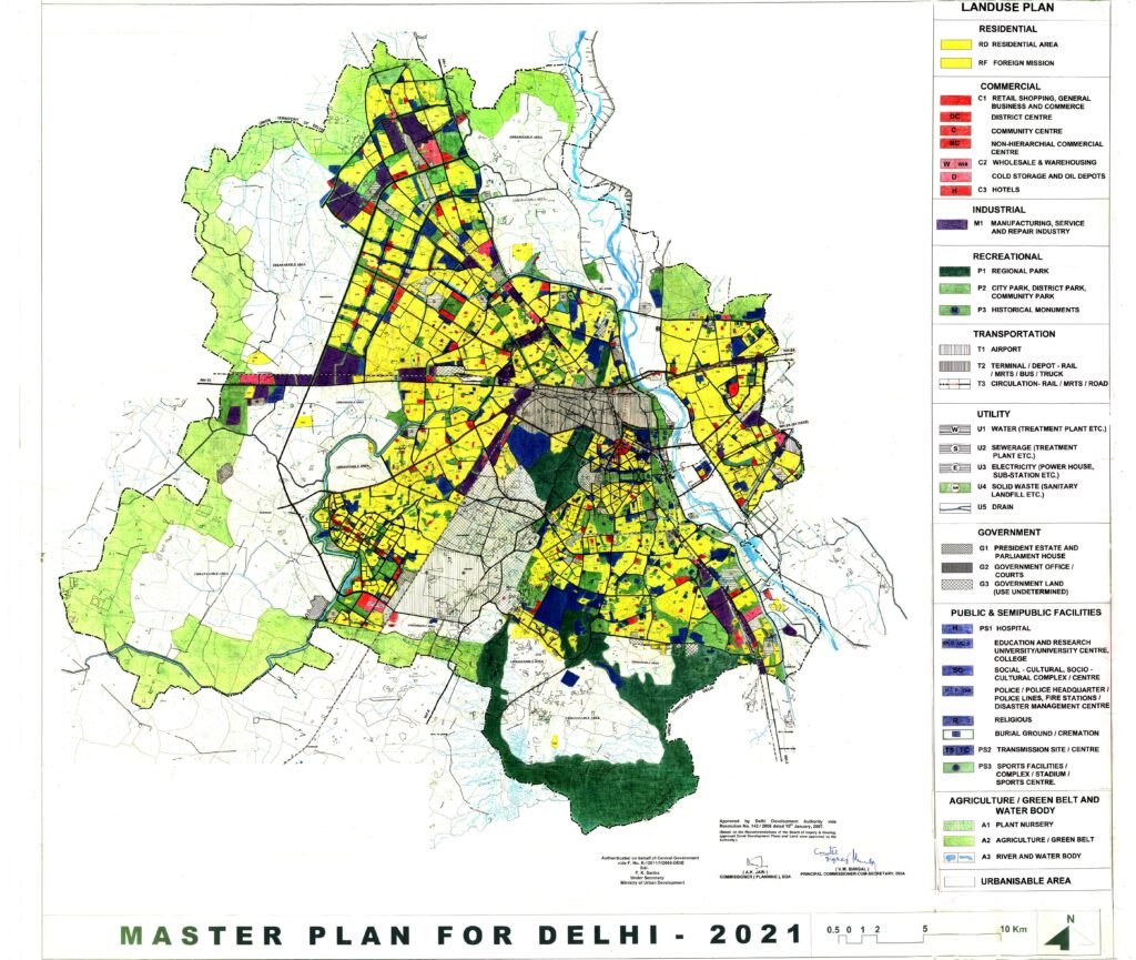
This issue has even been examined in legal proceedings. The opinion was clear: unless a new Master Plan is officially notified to supersede the existing one, the current plan continues to operate as the governing planning framework.
For example, the Master Plan for Delhi–2021 continues to remain in force because it has not yet been replaced. Over time, however, specific provisions can be modified through notifications to address emerging requirements. Policies such as Land Pooling, new development regulations and planning provisions for the Yamuna River zone have all been introduced through amendments while the Master Plan itself continues to provide the overall legal framework.
This illustrates an important distinction. The horizon year is primarily used for planning projections—estimating future population, housing demand, infrastructure requirements and public services. It does not prevent the Government from making modifications whenever circumstances require.
TheAPN: Then why was the 20-year planning cycle adopted in the first place?
A.K. Jain: Planning operates at multiple levels, each with a different time horizon. When we prepare a Master Plan, we do not think only in terms of twenty years. We normally work across three different planning horizons.
The first is the long-term vision. For major infrastructure such as transportation corridors, regional mobility systems, water resources or energy networks, planners often look 50 years or even further ahead. If a new expressway, metro corridor or water source is being planned today, it must be capable of serving future generations rather than merely addressing present-day demand.
The second horizon relates to medium-term development, which includes issues such as housing demand, employment, commercial growth and urban expansion. This is where the twenty-year planning framework becomes useful because it provides sufficient time for coordinated implementation.
The third horizon focuses on short-term priorities. Some issues cannot wait for two decades. Programmes such as slum rehabilitation, essential infrastructure upgrades and immediate public services require five-year or ten-year planning strategies with clearly defined implementation targets.
Planning therefore functions simultaneously across all three horizons. The twenty-year Master Plan provides the overall direction, while shorter-term programmes address immediate needs and the longer-term vision guides investments that may take decades to realise.
TheAPN: Population growth is one of the biggest uncertainties in urban planning. How do planners prepare for future demand when demographic trends keep changing?
A.K. Jain: Population forecasting is not a one-time exercise.
Whenever the DDA prepared a Master Plan, we constituted a dedicated demography group. This included experts from the Census of India, the Institute of Economic Growth and professional demographers who developed scientific population projections. These projections were prepared for different time horizons—five years, ten years and twenty years—not just for the final horizon year.
Housing requirements, infrastructure, transport networks, water supply, electricity demand and public facilities are all calculated on the basis of these evolving projections. As new census data become available, projections are reviewed and updated accordingly.
Planning is therefore a dynamic process. It is not a matter of preparing a twenty-year document and leaving it unchanged. The Master Plan provides the legal and strategic framework, while the underlying data, projections and development policies continue to evolve in response to changing realities.
MPD-2041: Why the Delay and What Should Change?
TheAPN: The Master Plan for Delhi–2041 is still awaiting approval. In your view, what has caused the delay?
A.K. Jain: I cannot comment on the Government’s internal decision-making because I am not involved in the present process. However, based on publicly available information and my understanding of the planning process, the draft Master Plan was prepared over several years but has remained pending with the Government for approval.
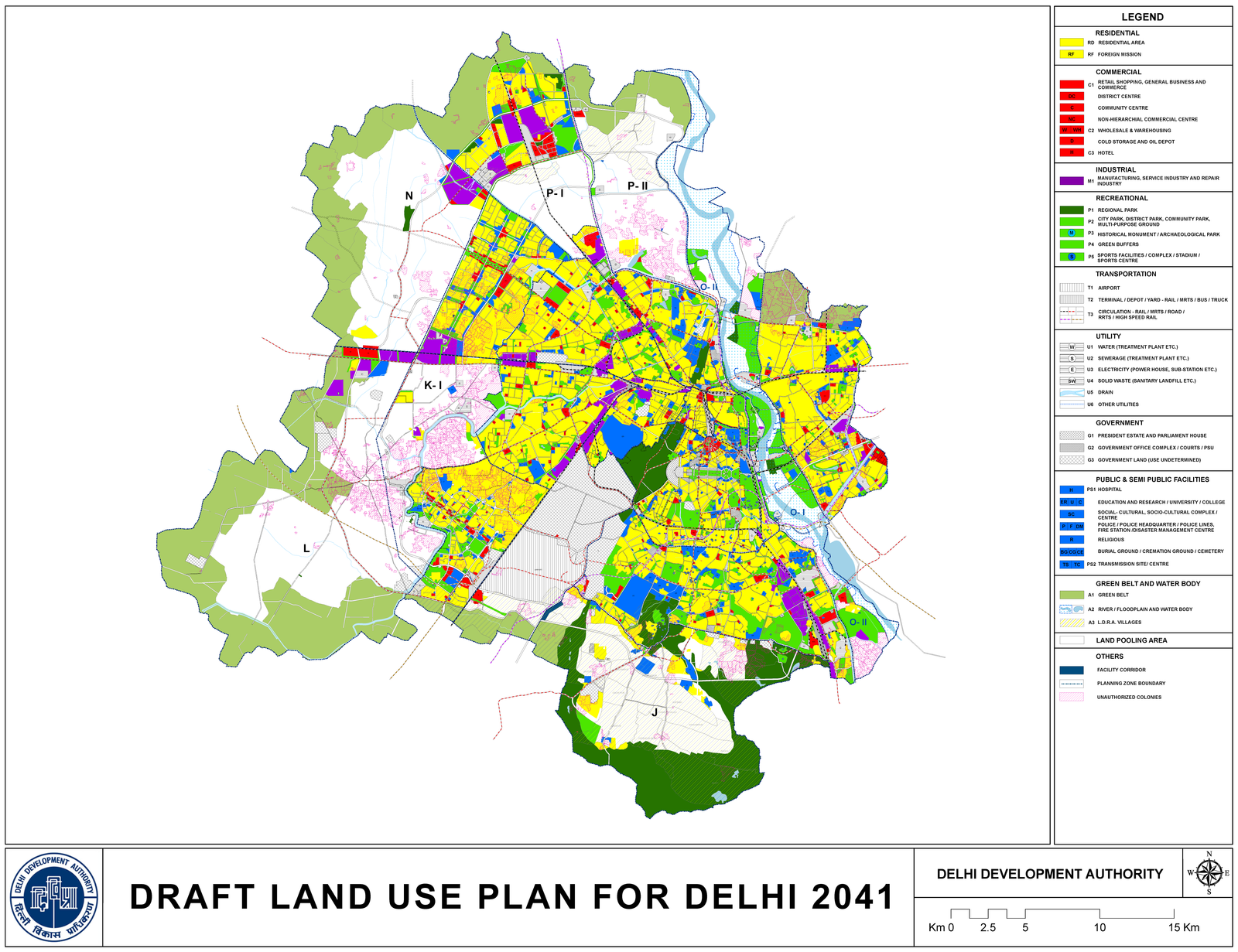
The work on the new Master Plan began around 2016–17. Unlike earlier plans, which were prepared largely within the Delhi Development Authority (DDA), this exercise was outsourced to the National Institute of Urban Affairs (NIUA) under the Ministry of Urban Affairs. After several years of preparation, the draft returned to the DDA, where it was approved in 2023 and subsequently forwarded to the Government of India for final approval. Since then, the plan has remained under consideration.
According to press reports, there are several sensitive issues that require careful consideration. One of the most significant concerns relates to Zone O, the Yamuna River zone. The proposal reportedly divides Zone O into two categories—a regulated area and a conservation area. This is a highly sensitive issue because any planning decision affecting the river corridor has major environmental implications. Environmental groups, as well as the National Green Tribunal (NGT), have consistently taken a strong position on protecting the Yamuna floodplain. In fact, there have been directions calling not only for restrictions on new construction but also for the removal of certain existing developments in environmentally sensitive areas. Given these concerns, any proposal relating to Zone O requires careful balancing between environmental protection and urban development.
Another issue is whether the target year should be 2041 or 2047. As the Government’s vision is Viksit Bharat@2047, the planning horizon should be aligned with 2047.
Also, many planners have questioned whether preparing only a twenty-year Master Plan is sufficient for addressing today’s rapidly changing urban challenges. A city like Delhi faces immediate issues such as air pollution, environmental degradation, housing shortages and infrastructure gaps. If these problems are not addressed within the next five years, a long-term Master Plan alone cannot deliver meaningful results. When plans extend over twenty years, many of the officials, planners and engineers associated with their preparation retire before implementation is complete. As a result, institutional continuity becomes difficult and accountability becomes diluted. Shorter strategic planning cycles would allow governments to review progress regularly, respond to changing circumstances and ensure that critical urban challenges are addressed without unnecessary delay.
The city may continue to have a vision extending to 2047, in line with the national objective of Viksit Bharat, but implementation should focus on practical priorities that can be achieved over the next five years. A strategic plan would identify urgent issues, define measurable actions and establish accountability for implementation.
A long-term vision remains essential for major investments such as transportation systems, regional infrastructure, water resources and energy planning. The long-term Master Plan provides the overall direction for the city’s future. However, alongside that vision, there should also be practical five-year implementation strategies that respond to current realities including aspects of slum redevelopment and land pooling, which have significant implications for Delhi’s future growth.
The vision can continue to evolve as circumstances change and as governments establish new priorities. But immediate urban problems require equally immediate action. Planning should therefore be both visionary and responsive—looking decades ahead while delivering measurable improvements in the present.
Editor’s Closing Note
Throughout this conversation, A.K. Jain traces Delhi’s planning journey from the foundations of Shahjahanabad to the contemporary debates surrounding MPD-2041. His reflections highlight that urban planning is not merely the preparation of maps and regulations; it is an evolving process that requires historical understanding, institutional continuity and the ability to balance long-term vision with immediate action.
The conversation doesn’t end here. In our next issue, we continue this insightful discussion with more thought-provoking questions and expert perspectives. Stay tuned—and keep reading!
This interview by TheAPN is part of its ongoing eff ort to facilitate professional dialogue, knowledge exchange, and encourage critical discourse on sustainable urban development among its readers. TheAPN extends its sincere gratitude to Ashok Kumar Jain for sharing his time, experiences, and valuable insights.
Also Read: Books that Reimagine India’s Rural and Urban Future: A. K. Jain
Join our WhatsApp Channel for fastest updates: Join now