A scientific study of Deodar trees in Batseri village of Himachal Pradesh’s Kinnaur district has revealed long-term shifts in Himalayan climate patterns and their growing link to geohazard events such as rockfalls and landslides. The research highlights how increasing spring droughts, driven by climate variability, are contributing to rising environmental risks in the fragile mountain region.

Conducted by the Birbal Sahni Institute of Palaeosciences (BSIP), an autonomous institute under the Department of Science and Technology, the study uses tree-ring analysis to reconstruct past climate conditions. The Deodar trees (Cedrus deodara) from the Sangla Valley along the Baspa River serve as natural climate archives, preserving centuries of environmental history within their annual growth rings.
The analysis indicates a transition from wetter spring conditions during the Little Ice Age to progressively drier springs after 1757 CE. In recent decades, especially after 1960, the frequency of spring droughts has increased significantly. These dry conditions have been closely associated with intensified geohazard activity in the region.
Using dendroclimatology and dendrogeomorphology, researchers reconstructed a 378-year record of spring moisture variability (1558–2021 CE) and a 168-year history of rockfall events (1853–2021 CE). The findings show that Deodar tree growth is highly sensitive to moisture availability during the spring months (February to April), which is largely influenced by winter precipitation brought by Western Disturbances.
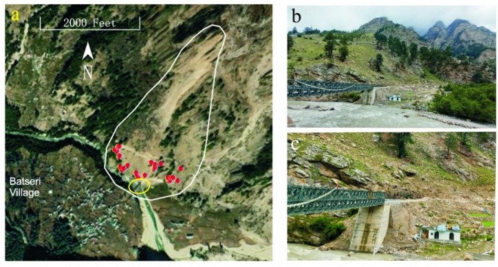
The study documented 53 rockfall events, including eight high-intensity incidents, many of which occurred during or after prolonged spring droughts. Dry conditions reduce vegetation cover and weaken slope stability, making mountainous terrain more vulnerable when intense monsoon rains follow. A notable example was the July 2021 rockfall near Batseri village, which damaged a bridge and residential structures, prompting further scientific investigation.
Researchers emphasize that understanding the relationship between climate variability and geohazards is critical for Himalayan regions facing increasing climate extremes. The findings underline the need for improved forest management, continuous slope monitoring, and early warning systems to reduce risks to settlements and infrastructure.
Published in the journal Catena, the study offers valuable insights for planners, policymakers, and local communities. By integrating climate reconstruction with hazard assessment, the research supports sustainable land-use planning, disaster preparedness, and climate adaptation strategies in vulnerable mountain environments.
Also Read: Meghalaya’s First Block-Level Climate Vulnerability Assessment Finds 25 Blocks at High Risk