The Geological Survey of India (GSI), the country’s nodal agency for landslide studies, has completed large-scale mapping of landslide-prone regions under the National Landslide Susceptibility Mapping (NLSM) programme. Covering around 4.3 lakh sq. km across 19 states and Union Territories, the initiative includes the Himalayan region, the Tertiary Belt of Northeast India, and the Western Ghats.
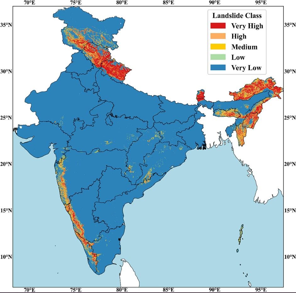
The susceptibility maps classify regions into high, moderate, and low-risk zones, providing crucial insights for regional land-use planning, infrastructure development, and community safety. GSI has also built a database of 91,000 historical landslides, with 33,904 validated through field studies. These datasets are accessible via the National Geoscience Data Repository (NGDR), Bhukosh portal, and the Bhooskhalan mobile app.
High-Resolution Mapping and Site-Specific Studies
Building on the NLSM baseline, GSI has advanced to meso-scale mapping (1:10,000/1:5,000). By the 2024–25 field season, it had completed work in 160 out of 200 critical sectors, identified in consultation with states. These high-resolution maps support zoning regulations and safer construction planning.
Additionally, in the last five years (2019–2024), GSI has undertaken 45 detailed investigations of chronic landslide sites on 1:1,000 to 1:2,000 scales, suggesting remedial measures for unstable slopes.
Early Warning and Forecasting Systems
To tackle the rising frequency of landslides, GSI has been developing a Regional Landslide Forecasting System (RLFS) since 2020. This system combines rainfall thresholds, weather prediction models, and real-time data in collaboration with IMD, NCMRWF, ISRO, and state disaster management authorities.
As part of the international LANDSLIP project, a prototype Landslide Early Warning System (LEWS) has been launched. Since the 2025 monsoon, experimental and operational landslide forecast bulletins have been issued for 21 districts across 8 states, including Darjeeling, Kalimpong, Nilgiris, Wayanad, Idukki, Rudraprayag, Chamoli, Shimla, and Kohima.
Government Support
The Government of India also provides financial support for disaster mitigation in vulnerable regions through the National Landslide Risk Mitigation Programme and the Aapda Mitra scheme of NDMA. The latter trains community volunteers to respond effectively to disasters.
This information was shared by Dr. Jitendra Singh, Union Minister of State (Independent Charge) for Science & Technology, Earth Sciences, and MoS PMO, in a written reply in the Lok Sabha.
Also Read: NMRC Invites Consultants to Design Noida Metro Aqua Line Extensions
Is this information available on Google maps / Map My India / Bharat Maps? It’ll help people in knowing the co-ordinates of places which are prone to landslides.
you can search in GSI and NLSM website.