URBAN SPRAWL IN INDIA: A Threat to Sustainable Development
1. Introduction
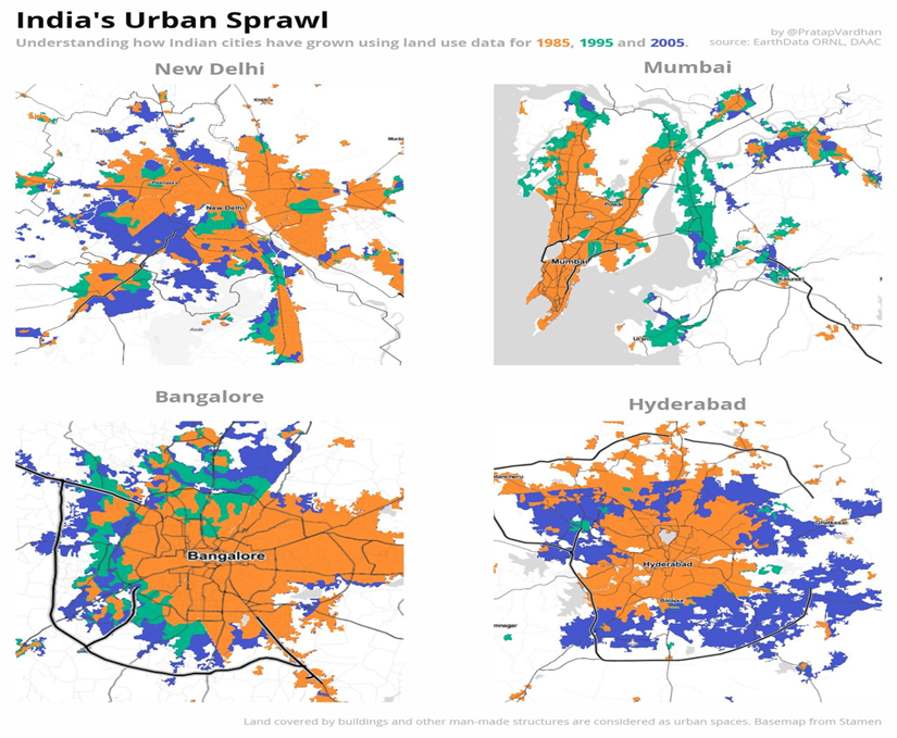
India is witnessing one of the fastest urban transitions in the world, with nearly 600 million people projected to live in cities by 2036 (National Commission on Population, 2021). However, much of this growth is neither compact nor efficient. Instead, it manifests in horizontal, low-density expansion—commonly known as urban sprawl. Unlike vertical, transit-supported growth found in planned cities, sprawl expands cities beyond their statutory limits, often engulfing villages, agricultural lands, and ecologically sensitive zones without adequate planning or infrastructure. For instance, the Hyderabad Metropolitan Region has expanded from 1905 sq. km in 2007 to over 7257 sq. km by 2021, driven by market forces and real estate speculation (GHMC Annual Report, 2021). This form of expansion fragments urban form, increases dependency on private vehicles, and puts immense strain on the environment and infrastructure.
Table of Contents
2. Factors of Urban Sprawl in India
One of the most prominent drivers of urban sprawl in India is the shortage of affordable housing in city cores, which pushes development to cheaper peripheral land. Developers, responding to demand from middle-income homebuyers, often build large gated communities on the fringes, such as in Greater Noida, Hinjawadi near Pune, or Whitefield in Bengaluru. These projects are frequently approved without considering long-term infrastructure costs or transport access. The growth of Whitefield, initially envisioned as an IT hub, soon led to residential sprawl with insufficient public transit, turning it into one of Bengaluru’s most traffic-congested suburbs (Jain, A., EPW, 2021).
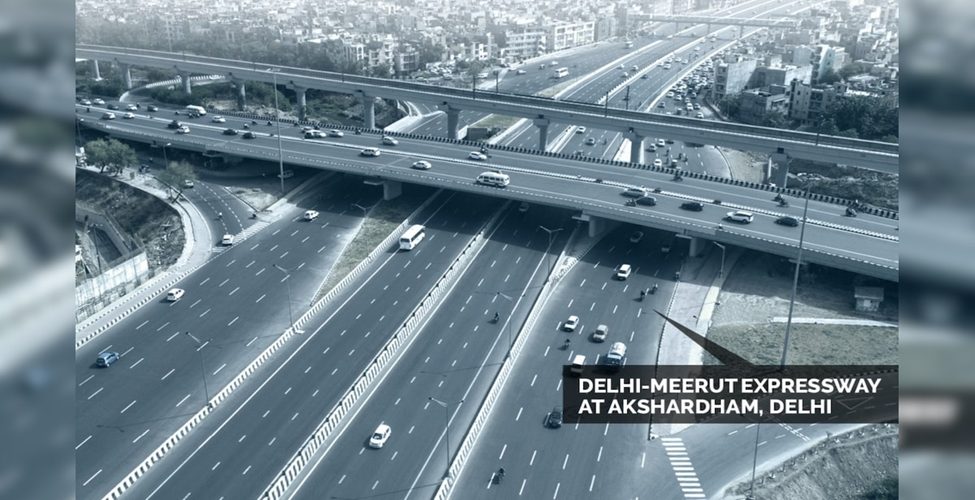
Another factor is infrastructure-led land unlocking. The Delhi–Meerut Expressway, constructed under the Bharatmala project, triggered a real estate boom along its corridor long before urban planning mechanisms could catch up. As a result, townships such as Rajnagar Extension and Modinagar emerged rapidly, yet suffer from water scarcity and waste disposal (MoRTH Project Report, 2022). Similarly, in Ahmedabad, the Sardar Patel Ring Road led to sprawling urbanization along its outer edge, outpacing the Ahmedabad Urban Development Authority’s (AUDA) capacity to provide amenities.
Reference- questionofcities.org
Reference- news18.com
Weak governance and fragmented planning institutions further accelerate the problem. Only 20% of Urban Local Bodies in India have GIS-based master plans, leaving peri-urban areas in a legal and planning vacuum (MoHUA, Urban Planning Capacity Report, 2021). Informal land conversion is common, especially where village panchayats control peripheral land without integrating it into metropolitan planning. In Nagpur, unauthorized layouts on the outskirts have become a parallel real estate market due to lax enforcement, resulting in sprawling colonies without roads or sewerage (Times of India, Nagpur Edition, 2024). For example, areas around Pune and Pimpri-Chinchwad have witnessed development due to the slow integration of newly urbanized zones into the municipal framework.
3. Environmental consequences of Urban sprawl India
Urban sprawl doesn’t just change skylines—it impacts nature in profound and often irreversible ways. As cities expand outward, they take away fertile farmland, grasslands, and water bodies. In Bengaluru, a study by the Indian Institute of Science (2020) found that over 80% of its green cover was lost in the span of four decades—much of it due to haphazard suburban growth.
Reference- cseindia.org
Sprawl also worsens the urban heat island effect.These hotter suburbs become not just uncomfortable but dangerous during peak summers, especially for the elderly and young children.
Water bodies and drainage systems are another major casualty. In Chennai, sprawling development on floodplains and lakebeds has led to flooding in recent years. Similarly, Gurugram’s urban villages, now surrounded by glass towers, suffer from seasonal waterlogging because natural drainage paths have been blocked by unplanned construction
4. Socio-Economic and Infrastructural Consequences
For those living in newly developed areas, life can be a daily struggle. Many such zones lack basic urban services: piped water, sewage networks, garbage collection, or reliable roads. A 2023 study by the Centre for Science and Environment (CSE) found that more than 50% of Delhi’s expanding suburbs lacked formal waste management, relying instead on illegal dumps or burning.
Residents often face long commutes, especially if their homes are distant from employment hubs. This reliance on private vehicles increases congestion and air pollution, with suburban areas now seeing spikes in PM2.5 levels, according to the National Clean Air Programme (2022).
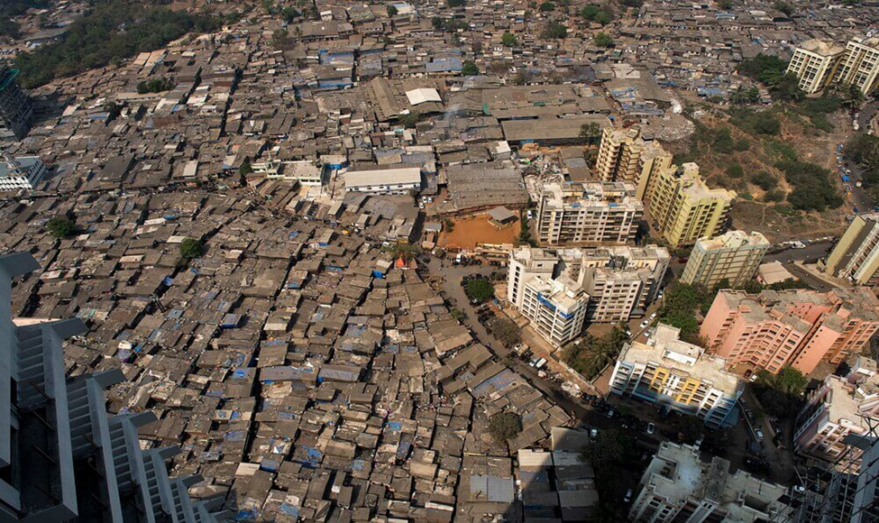
This uneven access also deepens inequality. On one end, we see high-income groups moving into gated enclaves with private security and swimming pools, while low-income migrants are relocated to far-off resettlement colonies with minimal infrastructure. In cities like Mumbai and Delhi, such displacement has led to a disconnect between where people live and where they work, increasing their travel time, expenses, and stress. This leads to development of slum areas like Dharavi. Mumbai almost covers 7.3% of Mumbai’s land area (Times of India). Dharavi slums is one of the largest slum in world over 1 million people reside 239 hectare of land (wikipedia)
5. The Planning Deficit
A major reason for India’s sprawl is the weakness of its urban planning systems. As per the Ministry of Housing and Urban Affairs (MoHUA, 2021), less than a quarter of Indian cities have current, GIS-enabled master plans. And even those often lack enforceability or public input.
Often, land-use plans do not align with transportation or environmental priorities. For example, while a city might build a metro line, it fails to rezone surrounding areas to support high-density, mixed-use development. This results in underutilized infrastructure and continued dependence on cars.
Some states like Gujarat and Maharashtra have attempted to counteract this through Town Planning Schemes (TPS) or Development Plans. Yet, implementation remains patchy. Without active citizen participation and data-driven monitoring, these plans risk becoming outdated blueprints gathering dust on shelves.
Also Read: Designing for Childhood: A Visit to National Bal Bhavan
6. A Path Forward: Compact and Inclusive Urbanism
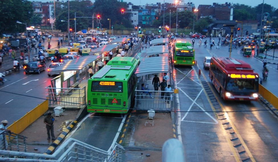
It’s not all gloom. Solutions exist—what’s needed is political will, smart governance, and citizen support. One promising approach is Transit-Oriented Development (TOD). Cities like Delhi, Pune, and Ahmedabad have begun to explore TOD, which encourages walkable, dense neighborhoods along public transport corridors. When done right, this reduces the need for cars, supports local economies, and lowers infrastructure costs.
Reference- thebetterindia.com
Reference- omlogic.com
Another important direction is regional planning. Cities must coordinate with surrounding districts to manage growth. The Surat Urban Development Authority, for instance, has created flood-resilient regional plans that integrate rural and urban needs. This kind of holistic thinking must become the norm, not the exception.
Technology can also help. Satellite data, real-time sensors, and GIS tools can track sprawl, monitor environmental impacts, and guide zoning decisions. Platforms like AMRUT 2.0 and the Smart Cities Mission are beginning to incorporate these tools, but their use must become widespread and mandatory.
Finally, involving citizens in shaping their neighborhoods is essential. When communities understand the consequences of sprawl—higher costs, weaker services, lost green spaces they can push for better planning and resist haphazard developments.
Conclusion
Urban sprawl might not always make headlines, but it is silently reshaping India’s cities—often for the worse. Left unchecked, it threatens to make urban life more unequal, less healthy, and less sustainable. But with careful planning, inclusive policies, and smarter design, we can chart a better course.
India is at a crossroads. Will our cities become fragmented zones of unchecked expansion? Or can we build compact, connected, and inclusive urban futures? The choices we make today will decide how livable our cities remain for generations to come.
References
- National Commission on Population (2021). Urbanization in India Report.
- MoHUA (2021). Urban Planning Capacity Building Report.
- Centre for Science and Environment (CSE, 2023). “Waste and Services in Peri-Urban India.”
- Indian Institute of Science (2020). Urban Growth and Vegetation Study: Bengaluru.
- Ministry of Environment, Forest and Climate Change (2022). NCAP Air Quality Report.
- Pune Municipal Corporation (2022). Hill Top Hill Slope (HTHS) Zoning Guidelines.
- Rockefeller Foundation (2021). ACCCRN Program: Surat Case Study.